Explore the East Cape Guide | New Zealand | Opotiki
  • Welcome
  • About Us
    • Maps >
      • Whakatane Map
      • Opotiki Map
      • Gisborne Map
      • Wairoa Map
      • Napier Map
      • Coverage Area
    • Accommodation
    • Bars | Restaurants | Cafe's
    • Things To Do
    • Groceries
    • FAQ's
  • Locations
    • Whakatane - Opotiki - SH2 >
      • Whakatane
      • Ohope Beach
      • Ohiwa Harbour
      • Waiotahe Beach
    • Opotiki - Te Kaha - SH35 >
      • Opotiki
      • Opotiki Accommodation
      • Opotiki Activities
      • Opotiki Business Directory
      • Opotiki History
      • Opotiki Prime Industries
      • Opotiki Restaurants, Cafes, Bars
      • Tablelands | Hukuwai Beach
      • Tirohanga | Omarumutu
      • Opape | Torere | Hawai
      • Maraenui | Motu | Omaio
    • Te Kaha - SH35
    • Whanarua Bay - Waihau Bay - SH35 >
      • Whanarua Bay
      • Raukokore
    • Waihau Bay - Hicks Bay - SH35 >
      • Waihau Bay
      • Oruaiti Beach
      • Whangaparoa (Cape Runaway)
      • Potaka | Lottin Point
    • Hicks Bay - SH35
    • Te Araroa - Ruatoria - SH35 >
      • Te Araroa
      • Tikitiki
    • Ruatoria - Tokomaru Bay - SH35 >
      • Ruatoria
      • Mt Hikurangi
    • Te Puia Springs - SH35
    • Tokomaru Bay - SH35
    • Anaura Bay - SH35
    • Tolaga Bay - Gisborne - SH35 >
      • Tolaga Bay
      • Waihau Beach
      • Te Tapuwae o Rongokako
      • Tatapouri
      • Mokorori | Okitu | Wainui Beaches
    • Gisborne - SH2 >
      • Gisborne
      • Gisborne - Accomodation
      • Gisborne - Cafes & Restaurants
      • Gisborne - Activities
    • Makaraka - Young Nicks Head - SH2
    • Morere - Nuhaka - SH2
    • Mahia- SH2
    • Wairoa - SH2 >
      • Wairoa - Accommodation
      • Wairoa - Places to Eat
      • Wairoa - Hunting & Fishing
    • Waikaremoana
    • Napier - SH2
  • Waioeka Journey
  • Motu Trails
  • Contact Us

Gisborne - Mahia - Wairoa - Waikaremoana

via State Highway 2 (Side Trip SH38)​

Picture
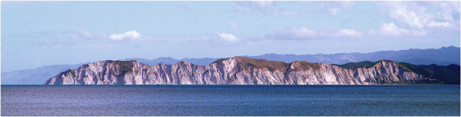
Young Nicks Head, Gisborne – Craig Willson Photography
Travel north-west from Gisborne along Gladstone Road. Just after the Gisborne Park Golf Course you will find the Showgrounds Park Motor Camp.
Gisborne Showgrounds Park Motor Camp
20 Main Rd, Makaraka.
P or Fx: 06-867 5299  E: camp@gisborneshow.co.nz

5km from Gisborne
Makaraka
94km from Wairoa
A busy little village at the junction of Main Rd & SH2.  Veer left onto SH2 where you will pass through the Poverty Bay flats. The opening of the Waipaoa River Flood Control Scheme in 1973 which protects 9,000 hectares has enabled the productive plains to belie their name,   and produce excellent wine and horticultural crops.

8km from Gisborne
Matawhero
91km from Wairoa
Picture
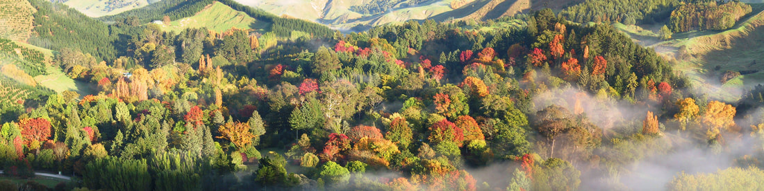
Morning time at Eastwoodhill Arboretum
This area is rich in Early-European history and a nearby farm was started in 1839. Originally a  school building, the Matawhero Historic Church was built in the 1860's. Matawhero is also the site of an infamous incident during the Māori Wars in 1868, when the warrior Te Kooti & his followers attacked the settlement, resulting in 54 deaths.

EASTWOODHILL ARBORETUM , RERE FALLS & RERE ROCK SLIDE SIDE TRIP
By turning right at the roundabout onto Wharekopae Road, you are heading towards, Eastwoodhill Arboretum (25kms) & the picturesque Rere Falls (40kms), picnic area  & swimming hole, & a bit past the falls is the Rere Rock Slide.  This 60 metre natural waterslide is suitable for most age groups, but it is recommended you wear a wetsuit or use a boogie board or inner tube.

13km from Gisborne
Manutuke
85km from Wairoa
Soon after turning left at the roundabout you will pass a side road leading to the village of Manutuke, the site of several interesting Māori marae. Te Poho o Rukupo is one of the oldest meeting houses in Poverty Bay, while Toko Toru Tapu, an Anglican church and the house Te Mana o Turanga on the Whakato Marae both have wonderful carvings. Please remember that marae are private property, if you are lucky you may find a friendly local to show you around.
Young Nicks Head
As you travel south you will look over the Wherowhero Estuary towards this striking peninsula, named after the surgeon's boy, Nicholas Young who spotted it from the masthead of Cook's  Endeavour on 6th October 1769.
After Muriwai the road leaves the plains behind & starts climbing through rolling sheep farms, forestry plantations of Pinus Radiata, and then the Wharerata Hill Scenic Reserve. The rest area at the summit of the hill (488m) provides magnificent views of Young Nicks Head and Poverty Bay towards Gisborne.
Morere

Opotiki

ETEC

Support

Accommodation
Things to Do
Places to Eat
About
Locations
Waioeka Journey
Contact
FAQ
Terms of Use
Picture
The Opotiki & District 10,000 club acknowledges the assistance of all those who have helped with photographs or content.
​New content material or suggested additions to this guide are welcomed. Please contact the Editor at P O Box 23, Opotiki.

All content of this guide is copyright to the Opotiki & District 10,000 Club Inc.and may not be used without prior consent.

© COPYRIGHT 2015. ALL RIGHTS RESERVED.

SidsWebdesignStudio
Picture
click to view the 2021 Guide
  • Welcome
  • About Us
    • Maps >
      • Whakatane Map
      • Opotiki Map
      • Gisborne Map
      • Wairoa Map
      • Napier Map
      • Coverage Area
    • Accommodation
    • Bars | Restaurants | Cafe's
    • Things To Do
    • Groceries
    • FAQ's
  • Locations
    • Whakatane - Opotiki - SH2 >
      • Whakatane
      • Ohope Beach
      • Ohiwa Harbour
      • Waiotahe Beach
    • Opotiki - Te Kaha - SH35 >
      • Opotiki
      • Opotiki Accommodation
      • Opotiki Activities
      • Opotiki Business Directory
      • Opotiki History
      • Opotiki Prime Industries
      • Opotiki Restaurants, Cafes, Bars
      • Tablelands | Hukuwai Beach
      • Tirohanga | Omarumutu
      • Opape | Torere | Hawai
      • Maraenui | Motu | Omaio
    • Te Kaha - SH35
    • Whanarua Bay - Waihau Bay - SH35 >
      • Whanarua Bay
      • Raukokore
    • Waihau Bay - Hicks Bay - SH35 >
      • Waihau Bay
      • Oruaiti Beach
      • Whangaparoa (Cape Runaway)
      • Potaka | Lottin Point
    • Hicks Bay - SH35
    • Te Araroa - Ruatoria - SH35 >
      • Te Araroa
      • Tikitiki
    • Ruatoria - Tokomaru Bay - SH35 >
      • Ruatoria
      • Mt Hikurangi
    • Te Puia Springs - SH35
    • Tokomaru Bay - SH35
    • Anaura Bay - SH35
    • Tolaga Bay - Gisborne - SH35 >
      • Tolaga Bay
      • Waihau Beach
      • Te Tapuwae o Rongokako
      • Tatapouri
      • Mokorori | Okitu | Wainui Beaches
    • Gisborne - SH2 >
      • Gisborne
      • Gisborne - Accomodation
      • Gisborne - Cafes & Restaurants
      • Gisborne - Activities
    • Makaraka - Young Nicks Head - SH2
    • Morere - Nuhaka - SH2
    • Mahia- SH2
    • Wairoa - SH2 >
      • Wairoa - Accommodation
      • Wairoa - Places to Eat
      • Wairoa - Hunting & Fishing
    • Waikaremoana
    • Napier - SH2
  • Waioeka Journey
  • Motu Trails
  • Contact Us