Waiotahe River & Ohiwa Beach (Bryans Beach)
At the Waiotahe River Bridge, turn left. At the first intersection, turn left to go to the harbour via the Ohiwa Harbour Scenic detour which takes you up over the hill. Take the right fork alongside the river, this non-exit road leads to the beautifully pohutukawa-lined sandy Ohiwa (or Bryan's) Beach, where you will find Ohiwa Seascape Studios. This secluded spot offers surfcasting, picnicking and safe swimming with plenty of shade.
At the Waiotahe River Bridge, turn left. At the first intersection, turn left to go to the harbour via the Ohiwa Harbour Scenic detour which takes you up over the hill. Take the right fork alongside the river, this non-exit road leads to the beautifully pohutukawa-lined sandy Ohiwa (or Bryan's) Beach, where you will find Ohiwa Seascape Studios. This secluded spot offers surfcasting, picnicking and safe swimming with plenty of shade.
|
Ohiwa Seascape Studios
3 Peaceful self-cont. studios offering absolute privacy, set amidst mature Pohutukawa, on the doorstep of Ohiwa Beach. 10 min to Opotiki. P: 07 315 4737 |

Continuing east along SH2 you will pass the Pipi Beds, there is a rest area on the left with toilets, safe swimming and at low tide you can see the locals gathering Pipi’s (shellfish). Next is the beautiful spectacle of Waiotahe Beach, with East Cape as a backdrop.
Waiotahe Beach
This stretch of road when the Pohutukawa trees are in bloom is a magnificent sight. Waiotahe Beach provides good fishing, surfing and swimming and is probably Ōpōtiki's most popular beach as there is adequate parking and picnic areas, with plenty of shade.
At the eastern end of the beach you will encounter two magnificently carved poles - Te ara Ki Te Tairāwhiti - "The pathway to the sunrise", designed by Graham Hayward and created by Ōpōtiki’s master carver, Heke Collier, they depict the arrival of the Māori people to Ōpōtiki, with the European Soldier and the Māori Wahine (woman) portraying the togetherness of the races.
Near the poles is the entrance to the Ōpōtiki Surf Lifesaving Club & public toilets. As you continue around the corner and start heading inland, you will see on your left the new subdivision of Waiotahi Drifts.
Near the poles is the entrance to the Ōpōtiki Surf Lifesaving Club & public toilets. As
you continue around the corner and start heading inland, you will see on your left the new
subdivision of Waiotahi Drifts.
This stretch of road when the Pohutukawa trees are in bloom is a magnificent sight. Waiotahe Beach provides good fishing, surfing and swimming and is probably Ōpōtiki's most popular beach as there is adequate parking and picnic areas, with plenty of shade.
At the eastern end of the beach you will encounter two magnificently carved poles - Te ara Ki Te Tairāwhiti - "The pathway to the sunrise", designed by Graham Hayward and created by Ōpōtiki’s master carver, Heke Collier, they depict the arrival of the Māori people to Ōpōtiki, with the European Soldier and the Māori Wahine (woman) portraying the togetherness of the races.
Near the poles is the entrance to the Ōpōtiki Surf Lifesaving Club & public toilets. As you continue around the corner and start heading inland, you will see on your left the new subdivision of Waiotahi Drifts.
Near the poles is the entrance to the Ōpōtiki Surf Lifesaving Club & public toilets. As
you continue around the corner and start heading inland, you will see on your left the new
subdivision of Waiotahi Drifts.
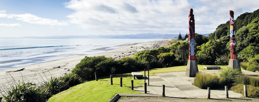
Waiotahe Beach looking East - Troy Baker
Continuing on the main road it is a short run through the Kukumoa cutting to view Ōpōtiki over the Waioeka River soon after the Ōpōtiki Golf Course comes into sight. If you are keen for a round - take a right before the bridge onto Woodlands Road, and a right again into Hukutaia Road. First on the right half way up the hill is Fromow Road where you will find the Ōpōtiki Golf Club house. If you wish to visit Hukutaia Domain & the Historic Tree - Taketakerau stay on Woodlands Road and continue for approx 7kms. You will also find Hikutaia Honey who do gate sales but please phone 07 315 7650 in advance.
Continue to the left over the Waioeka Bridge onto Bridge Street, ŌPŌTIKI. On the left is the New World Supermarket. Further on, a left turn onto Church Street you will find the ŌPŌTIKI CBD (Central Business District). If you continue on to the stop sign at St John Street intersection from here it’s a right turn to Gisborne via the Waioeka Gorge or a left turn will take you past The Hot Bread Shop Cafe...just around the corner, and Zandos Takeaways at Caltex Ōpōtiki a few blocks on, then to continue “up the coast” around the East Cape on SH35.