Explore the East Cape Guide | New Zealand | Opotiki
  • Welcome
  • About Us
    • Maps >
      • Whakatane Map
      • Opotiki Map
      • Gisborne Map
      • Wairoa Map
      • Napier Map
      • Coverage Area
    • Accommodation
    • Bars | Restaurants | Cafe's
    • Things To Do
    • Groceries
    • FAQ's
  • Locations
    • Whakatane - Opotiki - SH2 >
      • Whakatane
      • Ohope Beach
      • Ohiwa Harbour
      • Waiotahe Beach
    • Opotiki - Te Kaha - SH35 >
      • Opotiki
      • Opotiki Accommodation
      • Opotiki Activities
      • Opotiki Business Directory
      • Opotiki History
      • Opotiki Prime Industries
      • Opotiki Restaurants, Cafes, Bars
      • Tablelands | Hukuwai Beach
      • Tirohanga | Omarumutu
      • Opape | Torere | Hawai
      • Maraenui | Motu | Omaio
    • Te Kaha - SH35
    • Whanarua Bay - Waihau Bay - SH35 >
      • Whanarua Bay
      • Raukokore
    • Waihau Bay - Hicks Bay - SH35 >
      • Waihau Bay
      • Oruaiti Beach
      • Whangaparoa (Cape Runaway)
      • Potaka | Lottin Point
    • Hicks Bay - SH35
    • Te Araroa - Ruatoria - SH35 >
      • Te Araroa
      • Tikitiki
    • Ruatoria - Tokomaru Bay - SH35 >
      • Ruatoria
      • Mt Hikurangi
    • Te Puia Springs - SH35
    • Tokomaru Bay - SH35
    • Anaura Bay - SH35
    • Tolaga Bay - Gisborne - SH35 >
      • Tolaga Bay
      • Waihau Beach
      • Te Tapuwae o Rongokako
      • Tatapouri
      • Mokorori | Okitu | Wainui Beaches
    • Gisborne - SH2 >
      • Gisborne
      • Gisborne - Accomodation
      • Gisborne - Cafes & Restaurants
      • Gisborne - Activities
    • Makaraka - Young Nicks Head - SH2
    • Morere - Nuhaka - SH2
    • Mahia- SH2
    • Wairoa - SH2 >
      • Wairoa - Accommodation
      • Wairoa - Places to Eat
      • Wairoa - Hunting & Fishing
    • Waikaremoana
    • Napier - SH2
  • Waioeka Journey
  • Motu Trails
  • Contact Us
Picture
17km from Opotiki

Opape

317km from Gisborne
This is where the sandy beach ends amid the rocky inlets. Small fishing boats may be launched here to seek their way through the channel to the open sea. Eastern boundary of the Whakatōhea tribe, Opape is the site of the Muriwai meeting-house overlooking the sea. Here visitors can find a well equipped camping ground set well back off the main road and a newly developed coastal walkway.
Picture
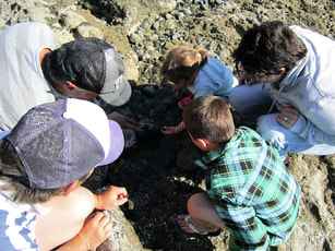
Whanau checking out a rockpool at Opape. Photo Ngaio Knebel
Opape Motor Camp
7 Opape Rd, Easy Beach access for Swimming or fishing. Powered & non powered sites.
P: 07 315 8020  W: www.opapemotorcamp.webs.com

24km from Opotiki

Torere

310km from Gisborne
As you come down onto the Torere Straight, a left just at the base of the hill is the road to the beach and Torere Macadamias, where they grow, harvest and process premium organic macadamia products.  Also onsite is New Zealand’s largest macadamia nursery supplying 95% of the macadamia plants in the country.
Torere Macadamias
Beachfront Orchard. Regular Field Days.
Picture
Torere is a large semi-circular bay, rocky at each extremity, and with a steeply shelving pebble beach, with deep water close to shore. Unsuitable for swimming but ideal for fishing. A lovely picnic area is situated on the western side of the bay beneath large pohutukawa trees. At the eastern end of the Bay the Bookbinders Road leads to some historic walkways, which include evidence of early Māori settlement on top of the hill and a whaling oven along the beachfront below the hill.  This is private property so a phone call would be a wise move.
A richly decorated church, serving the local Ngaitai tribe here, is worth inspecting, and the key can be collected at the nearby Runanga office where you will be directed to local points of interest and the various cottage industries. As you drive up the hill take time to see the magnificently carved Whakairo Gateway to Torere School.The Ngaitai tribe of Torere are descendants of Hoturoa’s daughter, Torere, who came ashore from the Tainui canoe on its journey along the coast from Whangaparaoa. The Tainui eventually terminated its journey from Hawaiiki at Kawhia, after being dragged overland from the Waitemata into the Manukau Harbour.

29km from Opotiki

Hawai

305km from Gisborne
A similar shelving beach to Torere, bare of trees, and usually covered with driftwood.  An excellent fishing spot, with river swimming and surfing at the eastern end of the beach.  This is the boundary area of Te-Whānau-ā-Apanui tribe, which extends to Cape Runaway.  Many tribal skirmishes have been reported about here - the old Ngariki tribe has Pā's in the hills - and the Hawai River, on the eastern side of this area, appears to have been part of one of the old tracks to the Gisborne plains in ancient times.
Picture

Opotiki

ETEC

Support

Accommodation
Things to Do
Places to Eat
About
Locations
Waioeka Journey
Contact
FAQ
Terms of Use
Picture
The Opotiki & District 10,000 club acknowledges the assistance of all those who have helped with photographs or content.
​New content material or suggested additions to this guide are welcomed. Please contact the Editor at P O Box 23, Opotiki.

All content of this guide is copyright to the Opotiki & District 10,000 Club Inc.and may not be used without prior consent.

© COPYRIGHT 2015. ALL RIGHTS RESERVED.

SidsWebdesignStudio
Picture
click to view the 2021 Guide
  • Welcome
  • About Us
    • Maps >
      • Whakatane Map
      • Opotiki Map
      • Gisborne Map
      • Wairoa Map
      • Napier Map
      • Coverage Area
    • Accommodation
    • Bars | Restaurants | Cafe's
    • Things To Do
    • Groceries
    • FAQ's
  • Locations
    • Whakatane - Opotiki - SH2 >
      • Whakatane
      • Ohope Beach
      • Ohiwa Harbour
      • Waiotahe Beach
    • Opotiki - Te Kaha - SH35 >
      • Opotiki
      • Opotiki Accommodation
      • Opotiki Activities
      • Opotiki Business Directory
      • Opotiki History
      • Opotiki Prime Industries
      • Opotiki Restaurants, Cafes, Bars
      • Tablelands | Hukuwai Beach
      • Tirohanga | Omarumutu
      • Opape | Torere | Hawai
      • Maraenui | Motu | Omaio
    • Te Kaha - SH35
    • Whanarua Bay - Waihau Bay - SH35 >
      • Whanarua Bay
      • Raukokore
    • Waihau Bay - Hicks Bay - SH35 >
      • Waihau Bay
      • Oruaiti Beach
      • Whangaparoa (Cape Runaway)
      • Potaka | Lottin Point
    • Hicks Bay - SH35
    • Te Araroa - Ruatoria - SH35 >
      • Te Araroa
      • Tikitiki
    • Ruatoria - Tokomaru Bay - SH35 >
      • Ruatoria
      • Mt Hikurangi
    • Te Puia Springs - SH35
    • Tokomaru Bay - SH35
    • Anaura Bay - SH35
    • Tolaga Bay - Gisborne - SH35 >
      • Tolaga Bay
      • Waihau Beach
      • Te Tapuwae o Rongokako
      • Tatapouri
      • Mokorori | Okitu | Wainui Beaches
    • Gisborne - SH2 >
      • Gisborne
      • Gisborne - Accomodation
      • Gisborne - Cafes & Restaurants
      • Gisborne - Activities
    • Makaraka - Young Nicks Head - SH2
    • Morere - Nuhaka - SH2
    • Mahia- SH2
    • Wairoa - SH2 >
      • Wairoa - Accommodation
      • Wairoa - Places to Eat
      • Wairoa - Hunting & Fishing
    • Waikaremoana
    • Napier - SH2
  • Waioeka Journey
  • Motu Trails
  • Contact Us