Explore the East Cape Guide | New Zealand | Opotiki
  • Welcome
  • About Us
    • Maps >
      • Whakatane Map
      • Opotiki Map
      • Gisborne Map
      • Wairoa Map
      • Napier Map
      • Coverage Area
    • Accommodation
    • Bars | Restaurants | Cafe's
    • Things To Do
    • Groceries
    • FAQ's
  • Locations
    • Whakatane - Opotiki - SH2 >
      • Whakatane
      • Ohope Beach
      • Ohiwa Harbour
      • Waiotahe Beach
    • Opotiki - Te Kaha - SH35 >
      • Opotiki
      • Opotiki Accommodation
      • Opotiki Activities
      • Opotiki Business Directory
      • Opotiki History
      • Opotiki Prime Industries
      • Opotiki Restaurants, Cafes, Bars
      • Tablelands | Hukuwai Beach
      • Tirohanga | Omarumutu
      • Opape | Torere | Hawai
      • Maraenui | Motu | Omaio
    • Te Kaha - SH35
    • Whanarua Bay - Waihau Bay - SH35 >
      • Whanarua Bay
      • Raukokore
    • Waihau Bay - Hicks Bay - SH35 >
      • Waihau Bay
      • Oruaiti Beach
      • Whangaparoa (Cape Runaway)
      • Potaka | Lottin Point
    • Hicks Bay - SH35
    • Te Araroa - Ruatoria - SH35 >
      • Te Araroa
      • Tikitiki
    • Ruatoria - Tokomaru Bay - SH35 >
      • Ruatoria
      • Mt Hikurangi
    • Te Puia Springs - SH35
    • Tokomaru Bay - SH35
    • Anaura Bay - SH35
    • Tolaga Bay - Gisborne - SH35 >
      • Tolaga Bay
      • Waihau Beach
      • Te Tapuwae o Rongokako
      • Tatapouri
      • Mokorori | Okitu | Wainui Beaches
    • Gisborne - SH2 >
      • Gisborne
      • Gisborne - Accomodation
      • Gisborne - Cafes & Restaurants
      • Gisborne - Activities
    • Makaraka - Young Nicks Head - SH2
    • Morere - Nuhaka - SH2
    • Mahia- SH2
    • Wairoa - SH2 >
      • Wairoa - Accommodation
      • Wairoa - Places to Eat
      • Wairoa - Hunting & Fishing
    • Waikaremoana
    • Napier - SH2
  • Waioeka Journey
  • Motu Trails
  • Contact Us

Motu Trails

nga haerenga | the new zealand cycle trail

Picture

Motu Trails

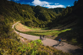
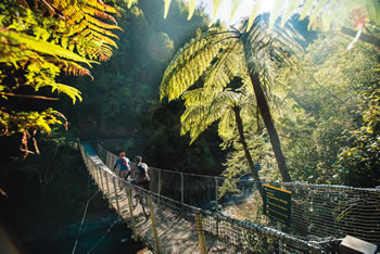
As one of the country’s 22 Great Rides, Motu Trails offers you fabulous cycling and walking opportunities. Choose from the family-friendly Dunes Trail, the historic heartland escape of the Motu Road Trail, and the classic adventure of the Pakihi Track.

You can ride all the trails in one big loop, if you wish staying with quality accommodation providers. Or, you can catch a shuttle up to Matawai, Motu, or beyond, and enjoy a ride with far more downhill than up. Wherever you go, this is an area rich in history, and in key places interpretation boards tell the stories of Maori and early settlers. Be set free!
Motu Community House
​
Self-catering accom. (up to 9 people) on Motu Trails. 18 Motu Falls Rd.
P: 06 862 8736 or 06 863 5804  E: shelley.paul@xtra.co.nz or rakanui@xtra.co.nz
​Motu Trails Hire and Shuttle
2 modern 11 seaters, S/C accommodation and camping right in the bush, group rates / packages our specialty.
P: 0800 MOTU TRAILS
Oasis Accommodation
30 King St. Ph 07-315 5165. Come home to a charming, friendly place after an exciting day out on the Motu Trails.
​The Boar’s Nest Accommodation and P.O.P Stop
P: 07-315 6554
Toatoa Farmstay Accommodation: Dinner, Bed, Breakfast, Packed Lunch. Safe Parking. Bike Hire.
​Biking & Gear Transport available to and from. Meet all needs, just ask.
P: 07-315 8340  W: 
www.toatoaaccommodation.co.nz
Weka Wilds
Self contained accommodation sleeps six (from $100). Woodfired meals available (pizza).
​Can cater to lunch groups.
Bookings: W: www.wekawilds.co.nz  P: 021-142 1515

Dunes Trail

Grade: Easy/Grade 2
Distance: 20 km return
Estimated Riding Time: 2 -3 hours
Access Points: Snell Road, Hikuwai Reserve, Pukeariki Beach Reserve, Wairakaia Road or Tirohanga Beach Road.
Recommended Riding Direction:Memorial Park Reserve to Jackson Road and return
Picture
More Details

Picture

Motu Road Trail

Grade: Intermediate/Grade 3
Distance: 78 km 
Estimated Riding Time: 4-7 hours
Access Points: Jackson Road or Matawai
Recommended Riding Direction: Matawai to Opotiki
More Details

Pakihi Track

​Grade: Advanced/Grade 4
Distance: 44 km 
Estimated Riding Time: 3 - 5 hours
Access Points: Motu Road ~ 17 km from Motu
Recommended Riding Direction: Motu Road - Opotiki
more details
Picture

Picture

Rere Falls Trail

Grade: Intermediate
Distance: 170km
Estimated riding time: 2-5 days
Start/finish: Gisborne, Opotiki
MORE DETAILS

Motu Trail Cycleway

Picture
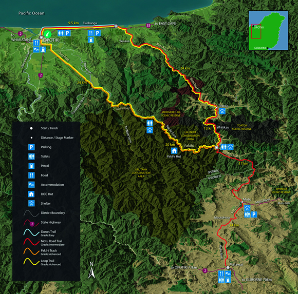
The Motu Trails is rideable all year round although expect the Motu Road Trail and Pakihi Track to be cold and damp in the depths of winter. It is best to check with the i-SITE Visitor Centres in Gisborne or Opotiki for current conditions.
The Motu Trails traverse a fairly remote area - so if you're planning a long ride you will need to go well prepared.
  • Check out www.motutrails.co.nz for full information, maps and more.
  • Visit https://www.facebook.com/motutrails for trail updates, news, photo's and more
  • Please support Motu Trails official partner businesses as they support the Trails. See
    the directory at www.motutrails.co.nz
Secure parking is available in Opotiki and Motu. Shelter areas and toilets are provided at Motu, top and bottom of the Pakihi Track, a shelter only at Toatoa and a camping area and a basic six-bunk DOC hut located 10kms down the Pakihi Track.
www.motutrails.co.nz or https://www.facebook.com/motutrails
​

info@themotutrails.co.nz
Opotiki i-SITE Visitor Centre, 70 Bridge Street, Opotiki. P: 07-3153031
Gisborne i-SITE Visitor Centre, 209 Grey Street, Gisborne. P: 06-867 2000

Opotiki

ETEC

Support

Accommodation
Things to Do
Places to Eat
About
Locations
Waioeka Journey
Contact
FAQ
Terms of Use
Picture
The Opotiki & District 10,000 club acknowledges the assistance of all those who have helped with photographs or content.
​New content material or suggested additions to this guide are welcomed. Please contact the Editor at P O Box 23, Opotiki.

All content of this guide is copyright to the Opotiki & District 10,000 Club Inc.and may not be used without prior consent.

© COPYRIGHT 2015. ALL RIGHTS RESERVED.

SidsWebdesignStudio
Picture
click to view the 2021 Guide
  • Welcome
  • About Us
    • Maps >
      • Whakatane Map
      • Opotiki Map
      • Gisborne Map
      • Wairoa Map
      • Napier Map
      • Coverage Area
    • Accommodation
    • Bars | Restaurants | Cafe's
    • Things To Do
    • Groceries
    • FAQ's
  • Locations
    • Whakatane - Opotiki - SH2 >
      • Whakatane
      • Ohope Beach
      • Ohiwa Harbour
      • Waiotahe Beach
    • Opotiki - Te Kaha - SH35 >
      • Opotiki
      • Opotiki Accommodation
      • Opotiki Activities
      • Opotiki Business Directory
      • Opotiki History
      • Opotiki Prime Industries
      • Opotiki Restaurants, Cafes, Bars
      • Tablelands | Hukuwai Beach
      • Tirohanga | Omarumutu
      • Opape | Torere | Hawai
      • Maraenui | Motu | Omaio
    • Te Kaha - SH35
    • Whanarua Bay - Waihau Bay - SH35 >
      • Whanarua Bay
      • Raukokore
    • Waihau Bay - Hicks Bay - SH35 >
      • Waihau Bay
      • Oruaiti Beach
      • Whangaparoa (Cape Runaway)
      • Potaka | Lottin Point
    • Hicks Bay - SH35
    • Te Araroa - Ruatoria - SH35 >
      • Te Araroa
      • Tikitiki
    • Ruatoria - Tokomaru Bay - SH35 >
      • Ruatoria
      • Mt Hikurangi
    • Te Puia Springs - SH35
    • Tokomaru Bay - SH35
    • Anaura Bay - SH35
    • Tolaga Bay - Gisborne - SH35 >
      • Tolaga Bay
      • Waihau Beach
      • Te Tapuwae o Rongokako
      • Tatapouri
      • Mokorori | Okitu | Wainui Beaches
    • Gisborne - SH2 >
      • Gisborne
      • Gisborne - Accomodation
      • Gisborne - Cafes & Restaurants
      • Gisborne - Activities
    • Makaraka - Young Nicks Head - SH2
    • Morere - Nuhaka - SH2
    • Mahia- SH2
    • Wairoa - SH2 >
      • Wairoa - Accommodation
      • Wairoa - Places to Eat
      • Wairoa - Hunting & Fishing
    • Waikaremoana
    • Napier - SH2
  • Waioeka Journey
  • Motu Trails
  • Contact Us